Namibian
Hotels, Lodges, Guesthouses & Camps
Check out the accommodation listings for each town,
city and major attraction in Namibia Town
Maps - Etosha - Fish River Canyon - Sesreim Namib Desert
Ariamsvlei Border
with South Africa south east open 24hrs
Aus North of Fish River
Canyon excellent base for exploring Luderitz and southern Namib
Desert
Bethanien Peaceful
village enroute to the Namib Desert
Brandberg Damaraland Namibias
tallest mountain, bushman paintings and burnt rock
Buitepos Border
with Botswana central west open 07h00 to 24h00
Caprivi Northern
Namibia stretch of well watered land between Zambia, and Botswana
Damaraland Petrified
forest, twyfelfontein, burnt mountain and more Central north west
Epupa on the northern border
with Angola with remote wonderful waterfalls
Etosha Wildlife in
a stunning surreal landscape
Fish
River Canyon Africa's largest canyon a beautiful spectacle in
the very south
Gamsberg Pass
south of Windhoek on the way to the Namib Desert
Gobabis Kalahari
town between Windhoek and the Botswana border
Grootfontein
Small town east of Etosha enroute to the north - Caprivi
Grunau crossroads
in the south where the B3 meets B1
Helmeringhausen
small farm town in the south on the edge of the Namib desert
Henties Bay coastal town
at the south of the Skeleton Coast
Kamanjab South Damaraland
and close to West Etosha
Kaokoland rugged unexplored northwest
area Himba tribe and amazing landscapes
Karabib halfway
between Windhoek and Swkopmund on the B2 tar road
Karasburg in the
very south of Namibia ideal stopover town
Katima Mulilo
in the very north west on the Zambezi River close to the Zambia
border
Kazungula ferry
crossing to Zambia in the very northwest
Keetmanshoop Quiver
trees dot the landscape near this southern town
Khorixas heart of Damaraland
and just west of Etosha Park
Kolmanskop deserted town
20km from Luderitz on the southern coast
Luderitz vibrant
harbour town on Namibias south coast
Maltahohe on the
edge of the Namib desert small sleepy town
Mariental on the
B1 road 270km south of Windhoek
Naukluft mountains
on the north of the namib desert good hiking and scenery
Ngoma northern border with botswana
open 07h00 to 18h00
Noordoewer southern
border with South Africa (Vioolsdrif) open 24hrs
Okahandja Namibias
garden town 90km north of Windhoek on the main B1 road
Okakarara
south of Waterberg plateau
Omaruru former cattle
farming centre of Namibia near the Erongo mountains
Ondangwa central
north Owamboland on the way to Angola
Opuwo Kaokoland administrative
centre and heart of Himba territory
Oshakati
Otavi small town on
the B1 road east of Etosha Park
Otjiwarongo
half way between Windhoek and Etosha on the main B1 road north
Outjo just south of
Etosha and gateway to Damaraland
Palmwag desert oasis famous
for desert elephant, rhino and lion - Damaraland
Rehoboth 90km south
of Windhoek on the main B1 road
Rosh Pinah on
the edge of the forbidden diamond area west of Fish River Canyon
Ruacana small town overlooking
beautiful Ruacana Falls
Seeheim old settlement
that now consists of one hotel just north of Fish River
Sesfontein remote outpost
in the Kaokaved north west
Skeleton Coast
harsh but beautiful northern coastline from Swakopmund to Angola
Solitaire thriving
small garage/farm on the Namib deserts edge famous for apple pie
Sossusvlei the dry pan in the
centre of the Namib Desert
Sesreim entrance into the Namib
desert and Sossusvlei
Spitzkoppe graceful
remote mountain peaks among the flat desert between Windhoek and
Swakopmund
Swakopmund popular
seaside town and activity centre of Namibia
Tsumeb busy town
on the B1 road north 90km from Etosha parks east gate
Twyfelfontein ancient
bushman paintings in beautiful stark landsacape in Damaraland
Damaraland north west
of Windhoek combination of desert, mountains and Skeleton Coast
Usakos half way between
Windhoek and Swakopmund on the tar B2 road
Velloorsdrift
southern border with South Africa open 08h00 to 17h00
Walvis Bay Namibias second
largest city and home to flocks of flamingoes, coastal city on the
edge of the desert
Waterberg a lost
world on a sandstone platter between Windhoek and Etosha Park
Windhoek small modern
capital of the country and centrally located
Map of Namibia

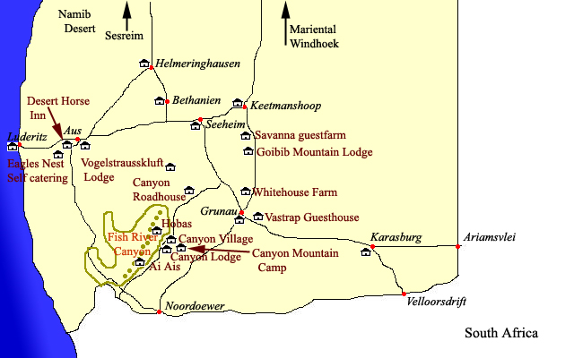
Fish River Canyon area Map

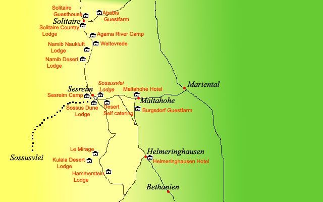
Namib Naukluft area map

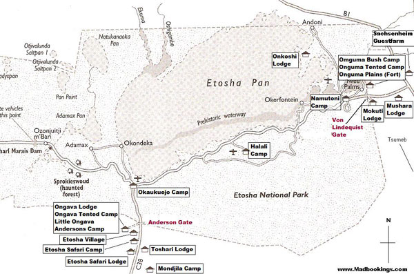
Etosha Park map

Useful stopover places around Namibia

|  Information on Namibia, location of hotels, lodges, camp sites, guest
houses, bed and breakfasts and places to saty in the Namibia. Distances
from major attractions in Namibia and information about shops, fuel and
facilities.


