Damaraland and Kaokoland
Find Your Perfect Stay, explore a variety of accommodation options that cater to every traveller's needs, from luxury lodges to camping and cozy guesthouses.

Damaraland
Damaraland is a unique and beautiful region that offers a blend of natural and cultural attractions. It is a great place to visit for anyone interested in experiencing the beauty and diversity of Namibia.

Kaokoland
The Kaokoveld is a rugged wilderness for the intrepid adventurer, accessible only by 4 wheel drive or light air craft. This part of Namibia is home to the Himba people and their traditional nomadic lifestyle.
Damaraland and Kaokoland Information Guide
The Spitzkoppe
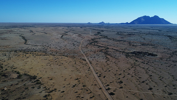
Between Usakos and Swakopmund Spitzkoppe is also described as the "Matterhorn of Namibia". Rising to a altitude of about 1800 metres, the Spitzkoppe is by no means Namibia's highest mountain, however, due to its striking outlines, it is regarded as the most well-known mountain in the country. Situated in an endless, dry plain, the island of mountains can be seen from far away.
The granite massif, which is part of the Erongo Mountains, was created by the collapse of a gigantic volcano more than 100 million years ago and the subsequent erosion, which exposed the volcanic rock, granite.
You can go for beautiful walks in this stunnung landscape and climb about between the bizarre rock formations. For those interested in flora, there is a lot to look at, like the yellow Butter Trees and the Poison Tree (euphorbia virosa), which leaks an extremely poisonous white juice; the Bushmen use this to poison their arrows.
San (Bushman) paintings
Can be found in various places, many in the "Bushman Paradise" under an overhanging rock wall. Despite appearances, it is quite difficult to climb the Spitzkoppe, first conquered in 1946. Only experienced and well-prepared mountaineers with adequate equipment should take this mountain on.
Kaokoland
Located in the north-west of Namibia is Kaokoland (also called Kaokoveld) one of the relatively untouched regions of Namibia. The almost inaccessible area south of the Kunene river, is home to the Himba ethnic group, who have kept their ethnic individuality and culture in the seclusion of Kaokoland. Travelling through this region should only be done in the company of an experienced guide and in off-road vehicles. Routes are hardly signposted, corrugated and extremely stony or sandy.
Van-Zyl's pass is regarded as the most difficult mountain pass in Namibia. The narrow track, leading through the rugged Otjihipa mountains, consists of coarse scree and jagged rocks. The gradients to be surmounted are quite extreme. For this reason, it takes about three hours to cover a distance of 10 kilometres by car. Only well-equipped four-wheel drive vehicles with powerful engines and good ground clearance are able to manage the trip.
The route to the Epupa Falls at the Kunene River is easy to drive on the C43. The stretch is rocky and rough, but well sign-posted and has neither difficult passes nor soft-sand tracks. However, after heavy rainfalls passing through the Ombuku riverbed near Okongwati can prove difficult.
The scenery at Epupa Falls is enchanting, with palm and baobab trees lining the riverbed. Above the waterfalls you find nice pools for swimming, but beware of crocodiles.
Himba People
The Kaokoland (Kaokoveld) offers tourists an insight into the traditional way of Himba life. Don't give begging children or adults items alien to their culture, especially no alcohol or medicines (even if they ask). Don't enter a Himba Kraal without permission and, of course, don't drive through a settlement.
The Himba Tribe who inhabit Kaokoland are the descendants of the earliest Hereros who migrated into this area in the 16th century. Around the middle of the 18th century the pressure of too many people and cattle in this dry, fragile environment led to the migration of the main body of the Herero to the rich pasture lands further south. The Himba are an ancient tribe of semi nomadic pastoralists, many of whom still live and dress according to ancient traditions and live in scattered settlements throughout Kaokoland.
They are a slender and statuesque people. The women especially are noted for their unusual sculptural beauty, enhanced by intricate hairstyles and traditional adornments. They rub their bodies with red ochre and fat, a treatment which protects their skins against the harsh desert climate.
The homes of the Himba are simple cone shaped structures of saplings bound together with palm leaves and plastered with mud and dung. A family may move from one home to another several times a year to seek grazing for their goats and cattle.
Kaokoland Fuel, Repairs and Food
There are limited petrol stations and services available in Koakoveld, except for the village of Opuwo situated on the margin of Kaokoland. In Opuwo services are also quite limited. If you plan to travel this remote area, you should stock up on water, groceries and fuel beforehand and make sure your vehicle is in good condition.
You need to have a range of at least 1000 kilometres if you want to drive through the valley of the Marienfluss to the Kunene and from there to Purros and Fort Sesfontein. Keep in mind that there is no cellphone reception so in the event of a break-down, you will be on your own. You may find it helpful to take a proper GPS device with you that you know how to operate.
Only four-wheel drives should enter the Kaokoveld. Consult your car rental before deciding on a trip through this adventurous area some car rental companies do not like their hire vehicles going to the Kaokaveld. Insist on getting 2 (good) spare tyres, a spare petrol can, tools and a good hilift jack. Expect you have to change a tyre in the Kaokoveld. Let someone explain to you where to put the jack on, make sure you know how to put the 4x4 into four-wheel mode.
Some stretches of road in the Kaokoveld are easy to travel, e.g. the route from Opuwo to Epupa Falls on the C43. Other roads require experience. Avoid the Van-Zyl's Pass if you are not used to driving four-wheel drives in difficult terrain. Don't travel the Kaokoveld, if it has been raining there.
Kaokoland is one of the last remaining wilderness areas in Southern Africa. It is a world of incredible mountain scenery, a refuge for the rare desert dwelling elephant, black rhino and giraffe and the home of the Himba people. Although it is harsh and offers little respite at midday, the rugged landscape is especially attractive during the early morning and late afternoon when it is transformed into softly glowing pastel shades.
The topography in the south of the area is characterised by rugged mountains which are dissected by numerous watercourses, but north of the Hoarusib River the scenery is dominated by table-top koppies. Still further north, the Otjihipa Mountains rise abruptly above the Namib floor to form the eastern boundary of the Marienfluss, while the west of the valley is defined by the Hartmann Mountains. The Marienfluss valley is very scenic and relatively greener than the Hartmann's valley. Hartmann's valley is closer to the Atlantic and yet much more arid. However, it does have a strange atmosphere when the sea mists drift inland.
Kaokoland differs greatly from Damaraland in terms of accessibility and infrastructure.
While Damaraland is quite isolated Kaokoland really is remote, large and for the most part empty. With a population of only 16,000 inhabitants, 5,000 of them Himba, Kaokoland has the lowest population density in Namibia - of only one person to every two square kilometres.
Kaokoland is bordered on the south the Hoanib River and on the north the Kunene River which also forms Namibia's border with Angola. Mountain ranges near the Kunene River are rugged and impressive with the highest point located at 2039m in the Baynes Mountains. It is unusual but the river runs through this arid landscape and the only real waterfalls in Namibia along it's path.
The Ruacana Falls are 120m high and 700m wide in full flood. Also along the Kunene River you'll find the Epupa falls, about 135km downstream from the Ruacana falls.
The name Epupa is a Herero work for the spume created by falling water. Epupa is formed by a series of cascades that drop a total of 60m over a distance of about 1.5km and at one point reaches a total width of 500m. It looks great for swimming but there are crocodiles waiting!
Near the hot water spring at Warmquelle is Sesfontein Fort which for many years was a desolate and rapidly disintegrating ruin. Almost a hundred years after it was first built, the historical monument, originally a police outpost, was reconstructed and equipped to accommodate tourists.
Sesfontein Fort derives its name from the six fountains which have their source in the vicinity. The palm trees at the fort were planted by the German police officers who manned the fort to combat weapons smuggling and elephant and rhino poaching.
Wildlife in Kaokoland
In terms of wildlife Kaokoland is probably most famous for it's desert elephant. The possibility of obtaining a glimpse, however brief, of a herd of desert dwelling elephants is what draws most tourists to the area. Between 1977 and 1982 a crippling drought gripped the area and wiped out large numbers of game. However, the biggest threat came from poachers, and between 1970 and 1983 the number of desert dwelling elephants in the Kaokoveld declined from an estimated 300 to 70.
Although the desert dwelling elephants are not a separate sub species they have adapted to their extremely harsh environment, the only other place in Africa where elephants live in such harsh conditions is in Mali on the edge of the Sahara Desert. The secret of their survival in the arid wastelands is an intimate knowledge of their limited food and water resources.
During the dry periods they will even dig deep holes to obtain water and in this way also provide other animals with water. Unlike other elephants which drink daily, these ones have been observed going without water for up to four days.
The black rhino of Kaokoland suffered a fate similar to that of the elephants and by 1983 the population in the east had been exterminated, while only a few individuals survived in the extreme western parts of Kaokoland which makes them a very rare sight. Nowadays, there are a few organisations doing their best to ensure the continuing existence of these rare and unique animals.


